When making a mountain bicycle route through the field it is very common for us to have doubts about whether certain paths are suitable for cycling or if, on the contrary, they are prohibited from passing cyclists.
In many cases these incidents are not properly marked. It is common that, in new mountain bike routes through unknown areas or after a mistake in a tour, you are lost and with paths that you did not know and have doubts about whether its passage will be prohibited.
There are several tools that will allow you to get out of this quagmire and know if the track, road or path can be crossed by bicycle. In this article we want to give you a series of instructions and basic advice to know how to identify the paths and paths suitable to travel by bicycle of those who are prohibited from passing. But first you have to talk about a very important factor when facing any Mountain Bike route through the mountain: that of the forecast.
Applications to consult and download routes
Before throwing you to make a new Bike Bike route or by complicated mountain paths, usually isolated and rare by people, it is essential to organize the route in advance.
This implies getting the
Track of the route and study the roads in navigation applications such as Google Earth, Google Maps, Wikiloc,
Strava or Komoot, the most used and extended by bikers around the world (although there are many more and also free as routes). It is also advisable to help a GPS device that can load that route or
Track and give real -time navigation instructions, either with the mobile itself or with an external device (of Garmin, Polar, Sigma, etc).
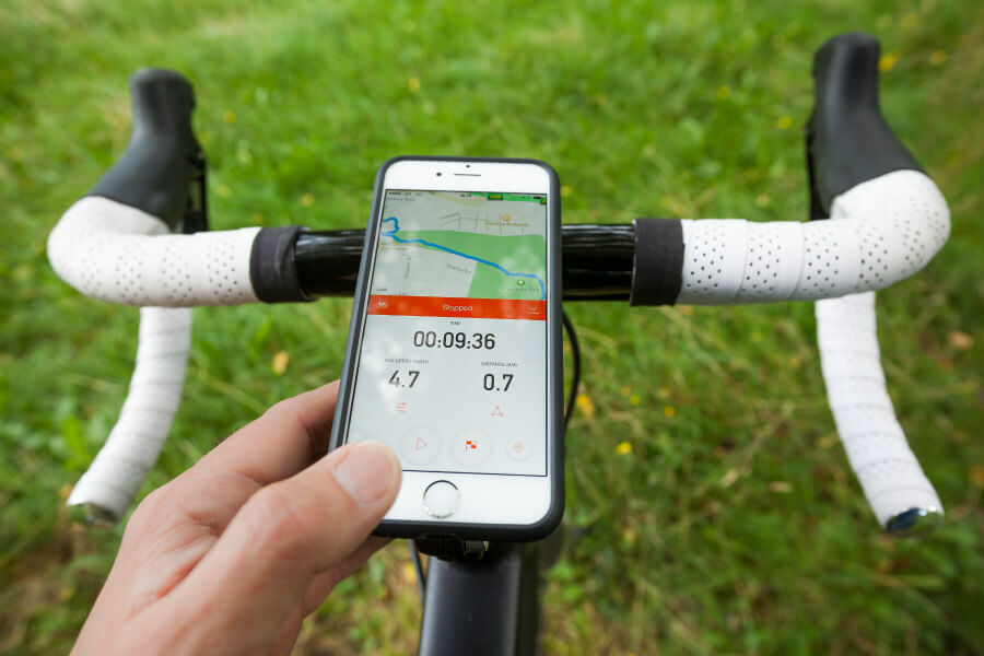
You don't have to have a state -of -the -art device to have browser on your bicycle and avoid losing yourself in the field. With easy -to -use applications and thousands of routes loaded by its users, such as the aforementioned Wikiloc and Komoot, it is possible.
Both have navigation function, the last one through voice, so it is not even necessary to carry the mobile installed in the handlebar to see the map. But to have operational the navigation function you must download the premium version of both.
On the SIGPAC website you can search
Also keep in mind that many user routes have some errors and are not updated. Before downloading the
Track Check the route's publication date well and read the description of the same, in case the author indicates an incidence on the route that is important to know.
Apart from the aforementioned mobile applications, which you can download well in the Google Play Store or in the Apple App Store (iPhone), there is the option to get with a
Cycocomputer with navigation function. The investment is larger, although it entails more advantages such as its most compact size and the greatest precision when giving indications about the layout.
Tools to know if a path is private or public
[Captation id = "Attachment_6638" Align = "Alignnone" Width = "900"]

(Image: DepositPhotos)[/caption]
In addition to shooting with a GPS device, you should make sure what type of lands are crossing and the ownership of the roads. It is possible that some of the mountains are protected. Or are intensive hunting grounds with roads cut in an open closure season (from October to February, mainly).
They are very relevant details that it is important to know to avoid problems with the owners of the farms and possible fines. A quick method to know if any of the roads of the route are private or public is to consult the website of the
SIGPAC, where you can look on an interactive map the different farms or plots of the area and the type of land and roads.
The prior consultation at the SIGPAC or on the website of the ownership of the roads will be very useful, not only to avoid fines or disputes with the owners but also to stop possible abuse of these, such as for example that a private one is marked as private Road that is for public use. If so, it is convenient to make strength with clubs and associations of cyclists or hikers in the area and denounce these practices that are illegal.
However, they are generally not very common and normal practices that private roads are well marked and fenced to avoid the entry of cyclists. Square signals are usually always with the written prohibition, closed metal doors or thick chains with a circular signal of prohibited passage.
Private hunting ground signals do not imply the prohibition of bicycle through their paths
On the other hand, in case you find a private hunting signal, the passage will be allowed whenever the opposite is not indicated with another signal. Of course, you must cross the preserve always keeping you on the road and without rolling through the adjoining terrain, which is not public.
Cyclable paths in reserves and natural parks
[Captation id = "Attachment_6421" Align = "Alignnone" Width = "900"]

(Image: DepositPhotos)[/caption]
In the case of protected natural spaces, whether regional, natural or national parks, the traffic of bicycles along the paths is limited to those marked as such, either with color indications in trees or stones and signs.
It is generally forbidden to deviate from these paths, delimited in this way with the aim of preserving the flora and fauna of the area. It is also possible that there are speed limitations or prohibitions for certain types of bicycle, such as electricity.
A previous recognition of the route and the review of the standards of the park will be very useful in this type of case, in addition to trying to find information about the state of the paths and whether they are practicable for a bicycle. In this sense, apps like
Wikiloc They function as a kind of online forum or social network where there are comments on the user route, detailing these incidents.
There are many cases in Spain of routes designed for hikers, whose paths for the state of the firm or the slope are impracticable for a mountain bike. Crossing them by bicycle is not a recommended practice. In addition to the danger of the irregularity of the terrain, the narrowness of the path or the slope, there is a risk of abuse to hikers.


